
TROPtastic
Member
- Oct 9, 2025
- 47
- 67
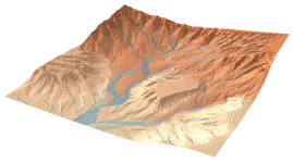
HintSystem on the KSA discord shared this novel erosion simulation technique that will be shown off in a SIGGRAPH 2026 paper. It seems to produce very realistic terrains by accounting for both material transport and geological erosion,
The techniques demonstrated in the paper and code should help with authoring realistic terrain. I'm not sure if this sort of stuff would be in the purview of @Linx , but it is worth taking a look at and seeing if it makes sense to use as part of the environmental art workflow for KSA.
resulting in the emergence of complex terrain features such as meanders, braided rivers and deltas, debris flow scars, and alluvial fans.
The techniques demonstrated in the paper and code should help with authoring realistic terrain. I'm not sure if this sort of stuff would be in the purview of @Linx , but it is worth taking a look at and seeing if it makes sense to use as part of the environmental art workflow for KSA.

Upvote
0